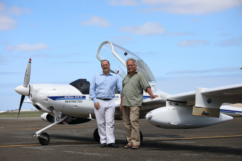
 Simon Hackett (left) with Jorg Hacker and an ARA plane
"“In many cases, remote sensing data taken from fire-affected areas disappears into a black hole"
Adelaide-based Airborne Research Australia is creating free 3D high-resolution maps of devastation caused by fires in the Adelaide Hills and Kangaroo Island to help communities recover and reduce future fire risks.
The maps, which contain unprecedented detail and are available from the Airborne Research Australia (ARA) website, are intended to assist communities, emergency services agencies and researchers to plan recovery from SA’s summer infernos, to better understand fire behaviour and develop future fire defence strategies.
ARA collects data for these high-resolution maps from low, slow flights by crewed motorgliders equipped with LIDAR *, hyperspectral sensors ** and high-resolution RGB cameras ***. ARA renders this mapping data in three dimensions (3D) and animates it as flythroughs to simplify viewing. Click here for an example, which was compiled using sophisticated software donated to this ARA project by Veesus Ltd in the UK.
ARA founder and Chief Scientist Jorg Hacker, who is also Professor Emeritus at Flinders University, said this high-resolution mapping data would help plan for community recovery and future fire prevention. “In many cases, remote sensing data taken from fire-affected areas disappears into a black hole, so the general public either never sees it or sees only a down-sampled low-resolution version,” he said.
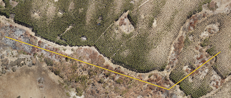 Taken January 27, 2020, this image is from near Western River in the north-west corner of Kangaroo Island. Brown indicates burnt areas, mainly in native eucalyptus forest and the black stumps leftover in burnt parts of the pine forest. Visible green areas show un-burnt or partially unburnt areas.
The image below shows a three-metre-wide vertical cross-section along the yellow line. Trees are displayed above the elevation profile (top graph) and as height above ground (bottom graph). The resolution of the pointcloud is so good that one can easily recognise even partly burnt trees.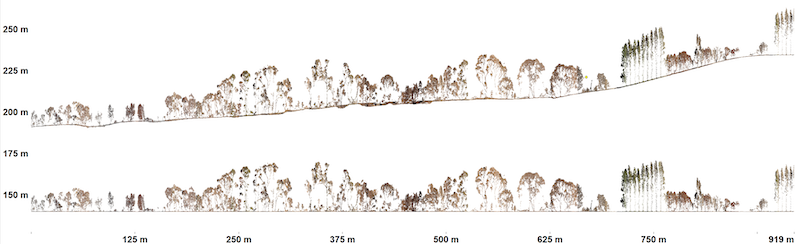
“We want to make all this data available to the public - the affected public especially - to help them recover their landscape, especially the natural landscape. For example, Kangaroo Island has some very deep gullies which the fires may have ‘jumped’ over, so the natural habitats may remain intact in these gullies. Our sensors can map in unprecedented detail landscape and forest features that are not visible with standard aerial photography or satellite data or from the ground.
“Our combination of LIDAR and hyperspectral sensors provide centimetre resolution detail. This lets us both detect the location of such habitats and the state and structure of the undergrowth with LIDAR and even the state of health of the surviving vegetation with hyperspectral scanning.
“We also want to make this data freely available to people in the research community so they can study it and use it to obtain insights that will help communities better prepare against fires and to assist fire defenders to plan their strategies against these unprecedented fire events.”
ARA is an Adelaide-based independent, not-for-profit research institute which grew out of Flinders University. From Parafield Airport, ARA operates purpose-designed aircraft carrying sophisticated sensing equipment. ARA’s detailed datasets are used for insights into economic and environmental issues ranging from land, air and water management to food production, mining, energy, coal seam gas fracking and climate change.
ARA began its fire flights after receiving a substantial donation from the Hackett Foundation, a philanthropic fund set up by Simon and Anna Hackett, which has provided significant financial support ARA in recent years. ARA will accept further donations via its website at https://www.airborneresearch.org.au/.
ARA flew its first fire flights over the Adelaide Hills in mid-January and its first two Kangaroo Island flights last week, focussing on the Ravine des Casoars Wilderness Protection Area.
Professor Hacker said the ARA maps were much more detailed than commercial aerial surveys. “In most cases, commercial surveys fly high in order to get coverage of large areas, so you don’t see details,” he said.
“Our planes are derived from a glider, so they can fly low and slow, with minimal fuel usage. We use less than 15 litres of premium unleaded petrol per hour. producing less pollution and less noise, compared with the smallest Cessnas, which use 40 to 50 litres of Avgas per hour. Drones are not a viable option for what we do because they cannot carry the sensors we’re using and are limited in their range. Our planes let us cover remote areas such as Kangaroo Island, flying from Adelaide.
“In the Adelaide Hills flights so far, which include burnt areas west of Woodside and Lobethal, plus some nature conservation areas, such as the Lobethal Bushland Park and the Porter Scrub Conservation Park, we were primarily interested in the natural environment, but there is overlap with other properties, so we have a lot of hi-res images of plant health and structure of the grapes by coincidence. You can see where vineyards and houses have burnt and where they haven’t. This provides valuable data for boundless research.”
For media assistance, including interviews and photographs, please call John Harris on 08 8431 4000 or email john@impress.com.au.
* LIDAR is a surveying system that uses light from a laser to measure distance to a target by illuminating it with laser light and measuring the reflected light with a sensor. Differences in laser return times and wavelengths can be used to make digital 3D maps of the target.
** VNIR (Visible and Near Infra-Red hyperspectral scanning measures light in 128 spectral windows (compared with four bands in a normal camera) in the visible and infrared light bands.
*** High-resolution RGB (Red Green Blue) cameras complement data from LIDAR and hyperspectral sensors to produce images with 6-8 cm pixel size over large areas of land.
About Airborne Research Australia (ARA)
ARA’s capabilities and approach to airborne environmental research and monitoring are unmatched worldwide in terms of the available sensing toolkit combined with the most cost-effective, flexible and clean airborne platforms available today operated by a small team of multi-talented specialists. Learn more about ARA at https://www.airborneresearch.org.au/.
Related News
- VAF demos $90,000 Sony 4K laser projector in SA Sony VPL-VW5000ESAdelaide’s premier audio-visual specialist VAF Research will this week display Sony’s latest and greatest 4K high definition laser projector - worth $9...
- Hackett Foundation sponsors WOMADelaide 2016 The charitable foundation run on behalf of the family of technology entrepreneur Simon Hackett has agreed to become the Presenting Sponsor of the WOMADelaide world music festival...
- Hackett ticks the boxes for Charles Todd Medal Internode founder and NBNCo board director Simon Hackett this week collected the Charles Todd Medal for his outstanding contributions to the Australian telecommunications industry....
- AvPlan takes off in the USA The internationally successful AvPlan software, which allows pilots of high performance planes to use an iPad to prepare and file their aircraft flight plans in just minutes, is no...


